Members Login
Username 
 
Password 
    Remember Me  
Post Info TOPIC: Wherezit?


Senior Member

Status: Offline
Posts: 286
Date:
Miss Piggy
Permalink Closed


That’s the right answer MBeans. Yup, I was mistaken - the answer was right there in Google Earth Communities. Nice image.

Miss Piggy is on the tourist map they hand you in Churchill (which also includes the failed incinerator and bear jail), but when you get to the airplane there’s a very stern “No Trespassing” sign.

Back to you!


__________________


Member

Status: Offline
Posts: 14
Date:
RE: Wherezit?
Permalink Closed


Ok, this is where I like to spend sunny afternoons.  However, I have only been there once and it was raining.    
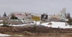
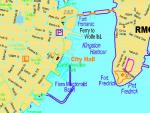
Coordinates are:  N 42° 20.775 W 071° 05.798


To log the correct answer you need to provide the nickname of this pole.


__________________


Veteran Member

Status: Offline
Posts: 39
Date:
Permalink Closed

That would be Fenway Park in Boston.  The pole would be known as Pesky's Pole. 

__________________


Senior Member

Status: Offline
Posts: 188
Date:
RE: Miss Piggy
Permalink Closed


Here's a picture of Miss Piggy's wilder side from May 2002.


Attachments
__________________


Senior Member

Status: Offline
Posts: 286
Date:
Flying Turdle
Permalink Closed


Very funny Dragonfreys! Here's a close-up of the pilot of the ill-fated aircraft:


__________________


Member

Status: Offline
Posts: 14
Date:
RE: Wherezit?
Permalink Closed


Pesky's Pole at Fenway Park is correct!  If you view the 3D image in Google Earth, they actually have the pole somewhere in right field

Attachments
__________________


Member

Status: Offline
Posts: 14
Date:
Permalink Closed

It's now time for a round of Double Wherezit!

This is an easy one, but provide the name of what is located at each of these locations:

N 47° 33'24.20 E 010° 44'57.81

N 28° 25'10.08 W 081° 34'52.15


__________________


Member

Status: Offline
Posts: 22
Date:
Permalink Closed

Those are two castles I visited last year.

The first one is Neuschwanstein Castle in Füssen, Germany.

Second one is the Cinderella Castle, in Walt Disney World, Orlando, Florida, loosely based on the first one architecturally speaking. 


-- Edited by ohmic at 00:33, 2007-01-20

__________________


Veteran Member

Status: Offline
Posts: 39
Date:
Permalink Closed

My turn:

N 44 13.773 W 76 28.788

Hopefully a little harder than just plugging the coordinates into GE.

Tell me what the building located here is and what its historical significance was to Canada's past.


__________________


Member

Status: Offline
Posts: 22
Date:
Permalink Closed

Since the GE map resolution is pretty limited , I can only assume that you are referring to the main building located East of the Rideau Canal. 

Fort Henry has been occupied as an active military site since 1789 and during the War of 1812 it served as the main naval station in Upper Canada. Ships of the Royal Navy were built and based here and it was because of these ships that the British army was able to preserve Upper Canada from American occupation.

Unless you're using GM, in which case it points to Confededration Park, where one of the Martello Tower, Victoria Tower also known as Shoal Tower was built  in the water in front of the Market Battery and City Hall, to increase the defense of Canada against an american take over following the War of 1812.

The strategic importance of Kingston in the defence of Canada was recognized and over a period of time the military and naval facilities were strengthened. The Rideau Canal was built to provide a safe logistic link from Montreal to the Dockyard, Fort Henry was rebuilt in stone, as were several dockyard buildings, and somewhat later, a series of towers were constructed to augment the harbour defences.


__________________


Veteran Member

Status: Offline
Posts: 39
Date:
Permalink Closed

While those are important historical landmarks nearby, that isnt what is located at the requested coordinates.   Good try ohmic.


-- Edited by candaceandwill at 22:16, 2007-01-19

__________________


Senior Member

Status: Offline
Posts: 188
Date:
RE: Kingston Building an Arch
Permalink Closed


How about the Confederation Arch in Confederation Park across Ontario street from City Hall?

Confederation was announced in Market Square near by. The park, which stands on the site of the former railway yards, was opened in 1967 to celebrate Canada's centennial. The confederation arch & fountain symbolize Canada as one nation from sea to sea.


Attachments
__________________


Veteran Member

Status: Offline
Posts: 39
Date:
RE: Wherezit?
Permalink Closed


Excellent!  I've spent many a summer wandering the downtown of Kingston while visiting family in the area. 

Where to next Dragonfreys?


__________________


Senior Member

Status: Offline
Posts: 188
Date:
Permalink Closed

Okay, how about up to the neighbourhood of my old stomping grounds.

59°47'8.35"N 137°54'42.48"W

This remote place may be a challenge, but it had the attention of most of North America's outdoors people in 1971 when someone did the impossible here. Wherezit and who did what to claim this one.


__________________


Member

Status: Offline
Posts: 14
Date:
Permalink Closed

The first known kayak descent of Turnback Canyon was by Dr. Walt Blackadar, who ran the canyon solo on August 25, 1971. He wrote about his trip for Sports Illustrated. "This has been a day!," he wrote in his journal. "I want any other kayaker or would-be expert to read my words well. The Alsek Gorge is unpaddleable!"

-- Edited by MBeans at 14:11, 2007-01-21

__________________


Senior Member

Status: Offline
Posts: 188
Date:
RE: Turnback Canyon
Permalink Closed


Yep, that's it. Note how wide the river is north of the canyon, before it gets funnelled into that narrow gorge. If you ever want a life altering experience rafting either the Alsek or Tatshenshini rivers through the coastal range will give you some new perspective. Mt. Logan is only about 100 km from there and you are on the fringe of the world's largest nonpolar icefields. The rafting tours down the Alsek have a helicopter fly their clients over Turnback Canyon when they reach it.

Well done MBeans, your turn.


__________________


Member

Status: Offline
Posts: 14
Date:
RE: Wherezit?
Permalink Closed


To log this find you need to name the person that you can see on the ground at these coordinates:

***disregard this post***


-- Edited by MBeans at 22:01, 2007-01-21

__________________


Veteran Member

Status: Offline
Posts: 44
Date:
Permalink Closed

Would that be Buffalo Bill, @ Buffalo Bill's, in Primm, Nevada?


-- Edited by Jimbo 2 at 21:35, 2007-01-21

__________________
28 grams of prevention is worth 454 grams of cure.


Senior Member

Status: Offline
Posts: 175
Date:
Permalink Closed

Cool Game.  I'm logging in to get notifications. Which are DEFINITELY required!


__________________


Member

Status: Offline
Posts: 14
Date:
Permalink Closed

Ok, my previous post was suposed to be coordinates to a giant cover of Maxim Magazine with Eva Longoria on the cover in the middle of the desert.  I don't know if it is a hoax or if the satalite images just aren't up to date.

Lets try this one instead.  This is easy, just post what is seen at these coordinates:

52°20'10.91"N 0°11'43.28"W


__________________


Veteran Member

Status: Offline
Posts: 44
Date:
Permalink Closed

An AIRPLANE!, flying over Huntingdon, England, no less.....

Please don't ask me what type it is.....


__________________
28 grams of prevention is worth 454 grams of cure.


Senior Member

Status: Offline
Posts: 188
Date:
RE: Avro Lancaster Bomber
Permalink Closed


Its an Avro Lancaster Bomber of WWII vintage returning from an airshow as I recall.

It looks like the Maxim cover was only there for a while and was since updated with new imagery, a google search for Maxim cover Primm Nevada will give you an idea of what used to be there.

I was wondering if you pulled it because it was too racey


__________________


Veteran Member

Status: Offline
Posts: 44
Date:
RE: Wherezit?
Permalink Closed


Dragonfreys wrote:

Its an Avro Lancaster Bomber of WWII vintage returning from an airshow as I recall.

It looks like the Maxim cover was only there for a while and was since updated with new imagery, a google search for Maxim cover Primm Nevada will give you an idea of what used to be there.

I was wondering if you pulled it because it was too racey


http://www.msnbc.msn.com/id/12186858/


__________________
28 grams of prevention is worth 454 grams of cure.


Member

Status: Offline
Posts: 22
Date:
Permalink Closed

What about my two castles? I'm still pending confirmation...

__________________


Member

Status: Offline
Posts: 14
Date:
Permalink Closed

The two Castles are right. My wife and I also visited the castles in Fussen Germany on our honeymoon and are going to Disney Castle in March!

__________________


Member

Status: Offline
Posts: 22
Date:
Permalink Closed

My interest in wildlife always makes me discover new and interesting facts and places.
Here's a cool one for you.

What used to be mined at this remote National Wildlife Refuge?

0° 22'00.00"S 160° 00'00.00"W

-- Edited by ohmic at 11:43, 2007-01-24

__________________


Veteran Member

Status: Offline
Posts: 33
Date:
Permalink Closed

Lets see......... I believe it is guano that was mined there, like so many other remote islands that have large bird colonies. The island is Jarvis Island.

-- Edited by dutch53 at 12:09, 2007-01-24

__________________


Member

Status: Offline
Posts: 22
Date:
Permalink Closed

Correct my friend!
Guano was mined heavily in the 1800's for fertilizer.
You're up.


__________________


Veteran Member

Status: Offline
Posts: 33
Date:
Permalink Closed


N 14 33' 31.62 W 90 44' 01.66


This location was once the capital of Central America but with in a couple of hundred years the capital was moved to what is now Guatemala City.  What was the reason for moving the whole city?

Today it is one of the main tourist attraction of the region, with many historical churches, public and private buidings.  It has a great market with many of the local people sell their products.

__________________


Member

Status: Offline
Posts: 9
Date:
Permalink Closed

Shortly after the Spanish conquest of Guatemala, the first capital was on a site part-way up this mountain. It was destroyed by a flood and mudslide when an earthquake let loose the water from the crater, and the capital of Guatemala was moved down the valley to the current Antigua. The original site is a village now known as "Ciudad Vieja", ("The Old City").

source: http://en.wikipedia.org/wiki/Antigua_Guatemala

cheers
Miles

__________________
«First  <  1 2 3  >  Last»  | Page of 3  sorted by
 
Quick Reply

Please log in to post quick replies.

Tweet this page Post to Digg Post to Del.icio.us


Create your own FREE Forum
Report Abuse
Powered by ActiveBoard